Segments
Segments
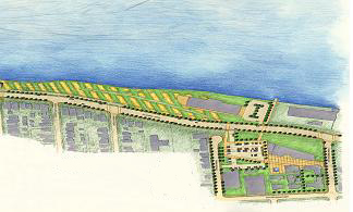
The Central Riverfront is divided into nine segments, beginning in the west at the Olde Sandwich Towne Community and ending in the east at Hiram Walker and Walkerville. Each segment contains descriptions of the major elements and destinations. The context, symbolic and thematic potential and proposed use of these elements is followed by general and specific recommendations.
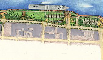
Segment 1 : West Anchor: Sandwich Community; McKee, Ambassador and Assumption Parks (Chewitt Street to Askin Avenue)
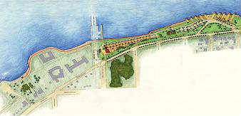 Represents the Central Riverfront's western anchor and gateway, emphasized by the presence of the Ambassador Bridge. Historically designated Assumption Park, south of Riverside Drive, it is well treed and links this segment of the riverfront to the neighbourhood on the south side of Riverside Drive. The following linking elements of this segment provide focal points and add to the enjoyment of the riverfront.
Existing
- Sandwich Entrance and McKee Park.
- Sculpture Garden (Odette Sculpture Park).
- Vietnam Memorial
Proposed
- Non-motorized Boat Launch
- Assembly Plaza
- Viewing, Resting and Fishing Stations
- Celestial Beacon
View Section 4.1 (Segment #1) in the Central Riverfront Implementation Plan.
Segment 2 : Centennial Park (Askin Avenue to Cameron Avenue)
 Provides linkage between the Celestial Beacon and the International Gardens and provides a setting for a passive recreational use area that incorporates the existing Sculpture Park, trails and landscaping. This segment includes the following features:
Existing
- Sculpture Park
- Trails
- Children's Play Areas
Proposed
- Sculpture Walk
- Chess/Checkers Tables
View Section 4.2 (Segment #2) in the Central Riverfront Implementation Plan.
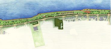
Segment 3 : International Garden (Cameron Avenue to Crawford Avenue)
 Located between Cameron and Crawford Avenues, this section represents a significant destination feature, linking the neighbourhoods south of Riverside Drive to the Central Riverfront. This area includes the following defining features:
Existing
- Former C.P. Ferry Docks
Proposed
- International Gardens
- "Canadian" Gardens
- Trails and Viewing Points
- Themed Meadow Planting
View Section 4.3 (Segment #3) in the Central Riverfront Implementation Plan.
Segment 4 : Outdoor Ecological Garden and Steamboat Wharf (Crawford Avenue to Church Street)
 Situated between Crawford Avenue and Church Street, this segment includes an outdoor ecological museum providing for a more naturalized park experience, the Legacy Beacon linking Windsor to its railroad past, and Steamboat Wharf. Identifying elements include:
Existing
- Riverside Drive Bridge Structure
- Caron Avenue Pumping Station
Proposed
- Naturalized Stormwater Management
- Interpretive Wildflower Meadow
- Legacy Beacon
- Theme Children's Secret Garden
- Steamboat Wharf West and East Buildings
View Section 4.4 (Segment #4) in the Central Riverfront Implementation Plan.
Segment 5 : Dieppe Gardens and CNR Parking Court (Church Street to Goyeau Street)
 Occurring between the Ecological Garden and Railroad Heritage Area this segment includes the existing Dieppe Gardens and Udine Fountain. Commemorative elements of this particular segment include:
Existing
- Dieppe Gardens
- Naval Monument
- Tour Boat Docking
- Udine Fountain
- Rose Garden Historic Brick Walk
- Peace Beacon and Plaza
Proposed
- Corporate Sponsorship Courtyard
- Historic Brick Walk
View Section 4.5 (Segment #5) in the Central Riverfront Implementation Plan.
Segment 6 : Civic Terrace, Festival Plaza (Goyeau Streets to Glengarry Avenue)
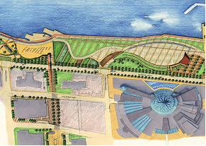 Located at the foot of the Civic Esplanade, between Glengarry Avenue and Goyeau Street, the Civic Terrace, Festival Green is a prime location for a wide range of festivals and events that links City Hall Square with the Central Riverfront. This segment offers the following:
Existing
- Civic Esplanade
- Festival Green
- Festival Plaza
- Railway Engine 5588
- Ferry Lifts
Proposed
- City Beacon
- Kinetic Display
- Corporate Sponsored Gardens
- Mist Wall
- Cruise Boat Dockings
View Section 4.6 (Segment #6) in the Central Riverfront Implementation Plan.
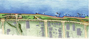
Segment 7 : Marina, Children's Water Spray Playground (Glengarry Avenue to Langlois Avenue)
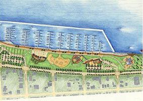 Includes the Marina and such active recreational uses as the Children's Water Spray Playground. The boardwalk promenade, beach volleyball courts and wave-like masses of landscaping that will promote and enhance the water concept. The following elements are included in this segment:
Existing
- Aylmer Comfort Station Children's Playground
Proposed
- Marina Building
- Volleyball Courts
- Skateboard Park
- Children's Water Spray Playground
View Section 4.7 (Segment #7) in the Central Riverfront Implementation Plan.
Segment 8 : Bert Weeks Memorial Garden, Great Western Park and Joan and Clifford Hatch Wildflower Garden (Langlois Avenue to Moy Avenue)
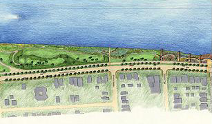 Positioned between the Marina and Hiram Walker's Distillery, the Bert Weeks Memorial Garden, Great Western Park and Joan and Clifford Hatch Wildflower Garden collectively create passive recreational areas that are also culturally, historically, and archaeologically significant. Segment 8 includes the following features:
Existing
- Dawn Beacon (1914 Pump House)
- Eastern Reach Shoreline
- Joan and Clifford Hatch Wildflower Gardens
- Great Western Park
Proposed
- Dawn Beacon
- Bert Weeks Memorial Garden
- Fountain Rest Facility
- Earth Mound
View Section 4.8 (Segment #8) in the Central Riverfront Implementation Plan.
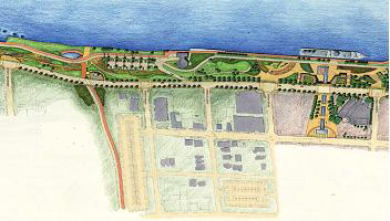
Segment 9 : East Anchor: Hiram Walker Distillery Walkverville (Moy Avenue to Walker Road)
 Representing the eastern anchor, this segment includes the Historic Walkerville area and the Hiram Walker site, providing a distinct entrance to the Riverfront. The unique heritage of this area, visible in the surroundings buildings, represents Hiram Walker's thriving distillery industry (founded in the late 19th century), linking the eastern trailhead to the historic and vibrant Town of Walkerville. Elements of segment #9 include:
Existing
- Historic Hiram Walker Lands
- Walkerville Distillery District
Proposed
- Recreationway
View Section 4.9 (Segment #9) in the Central Riverfront Implementation Plan.
For general information, contact 311. For detailed inquiries, contact us at:
Planning & Building Services Department
Planning Division
Suite 404, 400 City Hall Square East
Windsor, Ontario, Canada N9A 7K6
Phone: (519) 255-6543
Fax: (519) 255-6544
Email: planningdept@citywindsor.ca