In fill and Higher Density in Existing Built Areas
Objective C1: Encourage In-fill and Higher Density in Existing Built Areas
The following actions are needed to complete this objective:
- Promote concentration and encourage adaptive reuse of buildings, especially heritage buildings in core areas. These buildings already have infrastructure in place: streets, sewers, schools, transit.
- Identify opportunities for higher density development to support alternatives to driving (transit, cycling, walking, etc.).
- Examine current policies and by-laws; provide incentives for infill/higher density; set minimum density requirements.
- Design commercial and residential land use to maximize access to public transit.
- Support the existing Brownfields Redevelopment Strategy and implement its work plan.
- Continue the implementation of community improvement plans to encourage investment in older neighbourhoods.
- Monitor the success of the Brownfield Redevelopment Community Improvement Plan. Focus on beautification and renewal of existing built areas.
These indicators show the progress the City is making to achieve this objective:
- Population density in the core area of Windsor
- Number of records of site condition filed (indicator of how many brownfields are being repurposed)
Brownfield Conversion Indicator
"Brownfields" are abandoned, idled or underused properties where expansion or redevelopment is complicated by a real or perceived environmental contamination as a result of historical industrial or commercial land use practices.
Brownfields can have significant environmental, economic and social impacts on a community. Most brownfields are located in urban areas, and many are located in key areas such as downtowns. It is estimated that there are at least 30,000 brownfield sites in Canada.
Converting brownfields into productive sites can result in the following environmental benefits:
- Improvements to soil and water quality
- Reduction of urban sprawl
- Protection of existing green spaces and existing habitats
- Improvements to human and ecosystem health
How are we doing?
The City has completed a Brownfield Redevelopment Strategy which has an inventory of 141 brownfield sites that are candidates for redevelopment. Many of these are large industrial sites. Unfortunately the inventory does not include smaller commercial sites such as former gas stations or dry cleaners.
The number of redeveloped brownfields in Windsor can be tracked using the number of Records of Site Condition (RSC) filed for properties within the City. RSCs are required to be filed with the Ministry of the Environment and Climate Change any time a property moves to a more sensitive land use.
")
As shown in the graph above, the number of Records of Site Condition (RSCs) filed has increased steadily since 2017. There has been a steady increase every year since 2005 in the cumulative number, leading us towards our goal.
Note: In 2009 the Planning Department identified 137 brownfield properties (226 hectares or 550 acres) that are candidates for redevelopment. Inventory does not include gas stations. To date Council has approved forty-two (42) grant applications under the Brownfield Redevelopment CIP.
What's the City doing to promote Brownfield Conversion?
What can you do to promote brownfield conversion?
Population Density Indicator
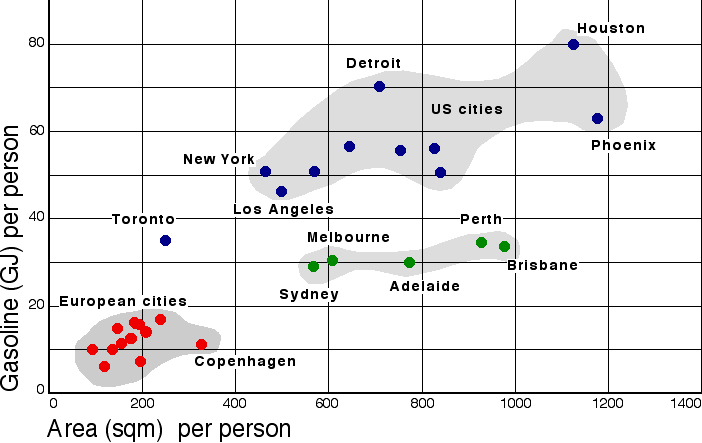
The concentration of people within the boundaries of the City of Windsor is a major influence on the choices people make about how to travel around the city. Options such as walking, bicycling, and using public transit are more viable in a compact urban area.
Density determines in large part the cost in money, energy, and resources to build and maintain public infrastructure. The greater the density in an urban area, the more its sewers and roads can be made compact. Certain modes of transportation (e.g. bus transit) require a certain level of urban density in order to be more efficient, in terms of energy use and operating cost relative to the number of people served.
In addition to infrastructure, density also influences the amount of fuel needed for automobile travel. The chart above suggests that cities with a higher overall population density (smaller area of land per person) also consume less gasoline than sprawling cities.
In 2005, the provincial government issued a Provincial Policy Statement (PPS). The statement requires municipalities to identify and promote opportunities for intensification and redevelopment.
Intensification means the development of a property, site or area at a higher density than currently exists through:
- Redevelopment, including the reuse of brownfield sites
- Development of vacant and/or underutilized lots within previously developed areas
- Infill development
- Expansion or conversion of existing buildings
How are we doing?

As shown in the chart above, Windsor's population density declined from 2006 to 2011, but a large increase has been noted in 2021 from 2011 and 2016 values. Note: 2007, 2012 and 2013 population data is predicted using Canada Census data from 2006 and 2011 respectively.
Note: In 2021, Windsor's population was 229,660, which represents a change of 5.7% from 2016.
For more information on population statistics, visit the City's Demographics Page.
What is the City of Windsor doing to increase urban density?
The City of Windsor has adopted a residential intensification target of 10 percent for the period 2006-2026. This means that 10 percent of all new residential development should be located within built-up areas of the city that have access to existing services such as roads and sewers. Based on the estimated housing demand during this 20-year period, 10 percent represents 1,968 housing units.
This target will be included in the City's updated Official Plan and will also be used for calculating the City's residential land needs over the long term.
It is worth noting that there are a limited number of large infill sites in Windsor, with the majority less than 1 hectare (2.47 acres) in size. Careful planning and design will be necessary to ensure that new development is sensitive to existing neighbourhoods. The Development Charges By-law 70-2010 (see By-laws Online) includes an initiative that offers partial exemption of development charges for residential infill development in core areas of Windsor. The purpose of this initiative is to encourage new residential construction or residential redevelopment in Windsor's downtown and historical community main streets through reduced development costs.
Other opportunities for infill include brownfield sites that are underused, vacant, or derelict. A brownfield may be contaminated and require cleanup in order to allow residential or commercial use. They are usually, but not exclusively, former industrial properties. The City has developed a Brownfields Redevelopment Strategy and Community Improvement Plan that will create incentives for the clean up and redevelopment of these properties.
Appropriate development standards can help to facilitate intensification, redevelopment and compact urban form. The City of Windsor is in the process of preparing a new Site Plan Control Manual that will set out standards that support walkable neighbourhoods and better urban design.
What can you do to promote increased urban density?
Stay informed about the monthly agenda for the City's Development and Heritage Standing Committee. Members of the public are welcome to provide comments on any planning application, such as a re-zoning, or land use change, either in writing or in person at a meeting of the Standing Committee. Upcoming agendas are posted on the Development and Heritage Standing Committee web page.
The public is also welcome to participate in the Housing and Homelessness Advisory Committee.
Ultimately, an increase in density depends on the decisions made by individuals regarding where to rent or purchase property. As demand rises for townhouses, multi-storey condominiums and housing in highly walkable mixed-use areas, developers will respond by gearing their projects to suit consumer demand for these options.
For more information on Environmental Initiatives
Email: emp@citywindsor.ca